Throughout our nearly six decades in the industry, we have used and maintained the latest GIS and Digital Mapping platforms in the office and in the field.
Meridian Surveys has decades of experience in GIS and digital mapping, including over 4000 data sets for federal and provincial mapping programs.
Our private sector work includes digital mapping, GIS, and CAD services for several of the largest pipeline and energy-based companies in Canada.
Digital Mapping
Our experienced staff of land surveyors, computer scientists, geographers, and technicians have at their disposal the latest tools and techniques of land surveying, remote sensing, Geographic Information Systems (GIS), Global Positioning Systems (GPS), and related forms of earth mapping. Utilizing modern desktop software platforms such as ESRI ArcGIS, Autodesk AutoCAD and customizable cloud-based GIS infrastructure through the industry leading ESRI ArcGIS Online and Enterprise platforms we can enable our staff and clients to make clear and concise data driven decisions.
At Meridian Surveys, we provide services to all sectors that require GIS services from urban and resource planning to large scale projects with geospatial components, and data warehousing and management.
Meridian Surveys has completed numerous pipeline conversion projects for companies such as TransCanada Pipelines and Pembina totaling over 42,000 kilometers.
Digital Mapping
Cutting-Edge Digital Mapping Solutions Tailored to Your Needs
Meridian Surveys offers a comprehensive suite of digital mapping services, backed by over four decades of industry experience and a commitment to innovation. Our GIS and Data Conversion services encompass a wide range of applications, including custom maps for presentations, large-scale data management, subdivision applications, pipeline GIS data conversion, and wildlife/natural resources management support. Whether you’re involved in gas and oil exploration, sea ice tracking, or topographic mapping, our team of experts delivers accurate and detailed topologically structured data for Geographic Information Systems (GIS), ensuring that you have the insights needed to make informed decisions and drive project success.
Digital Mapping
Unrivaled Expertise and Cutting-Edge Technology
With a track record of launching groundbreaking technology and maintaining a position at the forefront of innovation, Meridian Surveys is your trusted partner for digital mapping solutions. Our experienced staff, comprising land surveyors, computer scientists, geographers, and technicians, leverage the latest tools and techniques in land surveying, remote sensing, GIS, and GPS to deliver unparalleled results. Whether it’s parcel mapping and drafting, computer-aided drafting, terrain modeling, or aerial photography mosaics, we provide customized solutions tailored to your specific needs. With a proven track record of servicing some of Canada’s largest pipeline and energy-based companies, you can trust Meridian Surveys to deliver reliable, accurate, and efficient digital mapping services for your projects.
How We Help
Working with Meridian Surveys for digital mapping services means choosing a partner with over five decades of industry-leading expertise and a relentless commitment to innovation. With a proven track record of launching groundbreaking technology and maintaining a position at the forefront of the field, we offer unrivaled expertise in GIS, data conversion, and digital cartography. Our experienced team of land surveyors, computer scientists, geographers, and technicians utilizes the latest tools and techniques in land surveying, remote sensing, and Geographic Information Systems (GIS) to deliver accurate, detailed, and customized mapping solutions tailored to your specific needs. Whether you require custom maps for presentations, large-scale data management, or precise terrain modeling, Meridian Surveys provides reliable, efficient, and cutting-edge digital mapping services to drive the success of your projects.
GIS and Data Conversion
Services
Custom hard copy maps for presentations or displays.
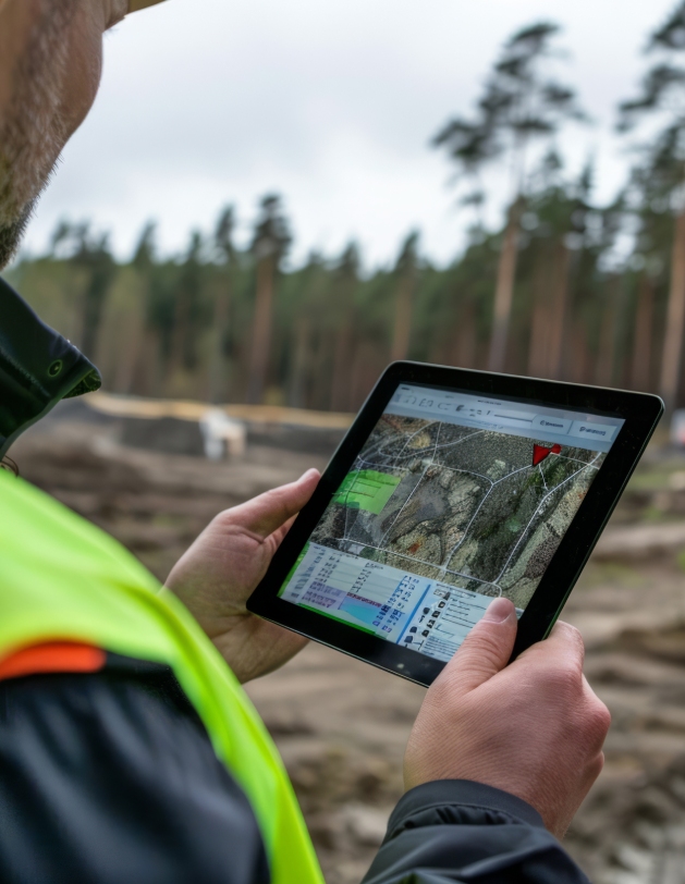
Customizable web mapping applications.
Ready to deploy mobile applications for data-enabled field workers.
Large-scale data information management.
Subdivision applications and liaison with approving agencies.
Pipeline GIS data conversion and solutions.
Gas and oil exploration and mapping.
Wildlife and natural resources management support.
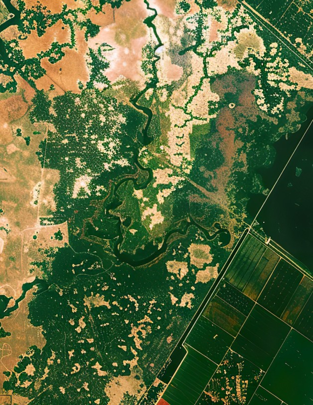
Topographic and cartographic mapping.
Geographic image analysis.
Accurate and detailed topologically structured data for internally or externally hosted GIS platforms.
GIS consulting, cadastral mapping, scan digitizing, thematic mapping, data conversion, data integration, and data maintenance.
Parcel Mapping and Drafting Services
At Meridian Surveys, we prepare parcel maps for land development, in accordance with all requirements, acts, and ordinances.
Our highly skilled professionals provide all necessary custom drafting, mapping and cartographic services for both the private and public sectors.
Services:
Computer aided drafting.
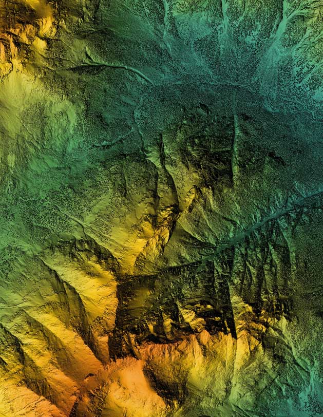
DEM and surface modelling, including contour maps.
Terrain modelling, including profiles, and cross-sections.
Remote sensing.
Digital cartography.
Topographic mapping.
Cadastral mapping.
Property mapping.
Parcel and subdivision mapping.
Thematic mapping.
Utility base mapping.
Aerial photography mosaics and geo-referencing.
Photo mosaics, including orthoimagery.
Compiled plans.
Perspective hill-shading and draping.
Geographic Information Systems
Meridian Surveys offers comprehensive Geographic Information Systems (GIS) solutions, including mapping management and municipal GIS services. With our GIS expertise, clients gain access to powerful tools for managing, analyzing, and visualizing spatial data, tailored to meet the specific needs of mapping management and municipal applications. Our mapping management services encompass the organization and maintenance of spatial data, ensuring data accuracy, consistency, and accessibility. From property boundaries and infrastructure assets to environmental features and demographic information, Meridian Surveys’ mapping management solutions provide clients with the essential tools to effectively manage and leverage their spatial data assets.
Geographic Information Systems
In addition to mapping management, Meridian Surveys specializes in municipal GIS services, providing municipalities with the tools and expertise to efficiently manage and utilize geographic information for decision-making and resource allocation. Our municipal GIS solutions encompass a wide range of applications, including land use planning, zoning regulation, infrastructure management, emergency response planning, and public service delivery. By leveraging GIS technology, municipalities can improve operational efficiency, enhance service delivery, and better respond to the needs of their constituents, ultimately fostering sustainable development and quality of life.
Lorem ipsum dolor sit amet, consectetur adipiscing elit. Donec vehicula porttitor felis sollicitudin porta. Suspendisse ut tincidunt est. Curabitur maximus porttitor risus, et tincidunt magna sollicitudin sed. Vivamus tempor eros erat, in semper eros molestie at. Sed non metus varius, dapibus dui non, vulputate quam. Sed convallis faucibus dui in semper. Nullam pretium, metus eget tincidunt posuere, nulla quam aliquam libero, et consequat lectus dui sed sapien. Vivamus venenatis felis in turpis ultrices rhoncus. Duis tincidunt nunc ut dui maximus, ac facilisis diam malesuada. Pellentesque eleifend tortor in aliquet pretium.Integer at ipsum luctus, mattis augue.
Step 1
Lorem ipsum dolor sit amet
Lorem ipsum dolor sit amet, consectetur adipiscing elit. Donec vehicula porttitor felis sollicitudin porta incididunt ut
Step 2
Lorem ipsum dolor sit amet
Lorem ipsum dolor sit amet, consectetur adipiscing elit. Donec vehicula porttitor felis sollicitudin porta incididunt ut
Step 3
Lorem ipsum dolor sit amet
Lorem ipsum dolor sit amet, consectetur adipiscing elit. Donec vehicula porttitor felis sollicitudin porta incididunt ut
Request A Quote
Enter your information below, and we’ll be in touch soon.